Lombok Island is a tropical paradise with magnificent stretches of natural beach, excellent diving and snorkelling off the three coral-ringed Gili Islands and traditional native villages, ancient temples and palaces. Mount Rinjani dominates Lombok with its high peak and two-mile wide caldera which last erupted in 1901. In the crater is a lake called Segara Anak (Child of the Sea) and a new mountain christened Gunung Baru which appeared in 1942. The people of Lombok are a gentle mix of Hindu-Balinese and native Moslem-Sasaks, each with their own variety of arts, crafts, customs and traditions. Many say that Lombok is like the Bali of long ago. The island lies across the straits from Bali and is quickly reached by ferry or plane.
 Once in Lombok, you can enjoy the peace and tranquility along its shores, or explore the island's largest towns of Ampenan, Mataram and Cakranegara. If you are fit you can trek up Mount Rinjani through scenic countryside and picturesque traditional villages and treat yourself to the most spectacular panoramic views.
The countryside has a number of traditional villages worth visiting, including a blacksmith's village, a native weaving village with dome-shaped thatched huts, and the royal water garden of Narmada in which stands the Pura Lingsar, the oldest and most sacred Hindu temple on the island, thought to be the only Hindu shrine in the world where both Hindus and Moslems come to worship.
Famous for its 'ikat' handwoven textiles, Lombok is relatively undiscovered, except for the town of Senggigi which is now a major resort.
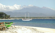
 The beautiful Gili islands of Lombok are paradise, with white sand beaches, few people and some great snorkeling and diving spots. Nightlife in this area may be a good alternative or even for a night dive; others are a complete escape from the crowds and offer some fabulous trekking and beautiful panorama for the more adventurous.
As well as scenery, Lombok offers terrific sightseeing and shopping, with some villages producing famous Lombok pottery and silk weaving at reasonable prices. Whether you get the car or motorbike and drive yourself, or arrange for a driver to show you the way, you will find a country with little influence yet from modern development and tourism. Even on the road, the bulk to traffic is the cidomo, or horse and cart.
When there are so much more of everything to see, meanwhile, you have such a limited time, a good planning becomes very essential to help you to make the most of your time away.
Lombok is an island in West Nusa Tenggara province, Indonesia. It forms part of the chain of the Lesser Sunda Islands, with the Lombok Strait separating it from Bali to the west and the Alas Strait between it and Sumbawa to the east. It is roughly circular, with a "tail" to the southwest, about 70 km across and a total area of about 4,725 km² (1,825 sq mi). The provincial capital and largest city on the island is Mataram.
The island has a population of 4,363,756 people (2008), 2,084,364 of these are female and 2,279,392 are male. The population is Sasak, Balinese, Tionghoa-peranakan (Chinese Indonesians), Sumbawa people, Flores people, and Arab Indonesian.
Geography
The Lombok Strait lies to the immediate west of the island and this waterway marks the passage of the biogeographical division between the fauna of the Indomalayan ecozone and the distinctly different fauna of Australasia that is known as the Wallace Line, for Alfred Russel Wallace, who first remarked upon the distinction between these two major biogeographical regions and how abrupt the boundary was between the two biomes.
To the east of Lombok lies the Alas Strait, a narrow body of water separating the island of Lombok from the nearby island of Sumbawa to the east.
The island's topography is dominated by the centrally-located stratovolcano Mount Rinjani, which rises to 3,726 m (12,224 ft), making the second highest volcano in Indonesia and the nations third highest mountain. The most recent eruption of Rinjani was in May, 2010 at Gunung Barujari. Ash was reported as rising up to two km into the atmosphere from the Barujari cone in Rinjani's caldera lake of Segara Anak. Lava flowed into the caldera lake, pushing its temperature up and crops on the slopes of Rinjani were damaged by ash fall. The volcano, and its crater lake, 'Segara Anak' (child of the sea), are protected by the Gunung Rinjani National Park established in 1997.
The highlands of Lombok are forest clad and mostly undeveloped. The lowlands are highly cultivated. Rice, soybeans, coffee, tobacco, cotton, cinnamon, cacao, cloves, cassava, corn, coconuts, copra, bananas and vanilla are the major crops grown in the fertile soils of the island. The southern part of the island is fertile but dryer especially toward the southern coastline.
The water supply in Lombok is stressed and this places strain upon both the water supply of the provincial capital, Mataram, and the island in general. The southern and central areas are reported to be the most critically effected. West Nusa Tenggara province in general is threatened with a with water crisis caused by increasing forest and water table damage and degradation. 160 thousand hectares of a total of 1960 thousand hectares are thought to have been effected. The Head of Built Environment and Security Forest Service Forest West Nusa Tenggara Andi Pramari stated in Mataram on Wednesday, May 6, 2009 that, "If this situation is not addressed it can be expected that within five years it may be difficult for people to obtain water in this part of NTB (West Nusa Tenggara). Not only that, the productivity of agriculture in value added will fall, and the residents are experiencing water deficiency in their wells". High cases of timber theft in the region of NTB are contributing to this problem. In September 2010 Central Lombok some villagers were reported to be walking for several hours to fetch a single pail of water. Nieleando, a small coastal village about 50 kilometers from the provincial capital, Mataram, has seen dry wells for years. It has been reported that occasionally the problem escalates sufficiently for disputes and fighting between villagers to occur. The problems have been reported to be most pronounced in the subdistricts of Jonggat, Janapria, Praya Timur, Praya Barat, Praya Barat Daya and Pujut. In 2010 all six sub-districts were declared drought areas by provincial authorities.
Tidak ada komentar:
Posting Komentar